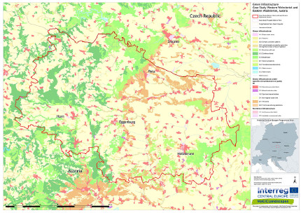
Eastern Waldviertel & Western Weinviertel, Austria
The case study area is covering the districts of Horn and Hollabrunn located in Lower Austria on the border with the Czech Republic: The Eastern Waldviertel is shaped by the highlands of a shallow gneiss landscape and the river Thaya, which has carved characteristic canyons there. Due to the combination of loamy, clayey sediments and loess deposits this region is more fertile than other parts of the area and is therefore characterized by agriculture (mainly wheat, rye, triticale and barley). The previously predominant wet meadows were drained and improved a long time ago, so that they are almost nonexistent nowadays. The remaining meadow lands are mainly improved meadows dominated by foxtail grass, tall oatgrass or golden oatgrass.
In this agricultural landscape forests and copses with red pines, pioneer plants (birch, aspen, sweet cherry) and common oak form important centres of biodiversity and provide habitats for plants and numerous animal groups (e.g. as refugium for amphibians and reptiles or breeding areas for birds including birds of prey such as Montagu's harrier (Circus pygargus), great grey shrike (Lanius excubitor), western marsh harrier (Circus aeruginosus) or the grey partridge (Perdix perdix)).
From a conservation point of view it is a big advantage that the Eastern Waldviertel does not have any highly developed infrastructure (e.g. there is neither a motorway nor a single high-voltage line nor any wind farms) and only a few tourist attractions. More information can be found on the website of our associated partner, the Austrian League of Nature Conservation Lower Austria (in German).
The Western Weinviertel is characterized by wide open valleys and molasse sediments with rolling hills. To the west, the Manhartsberg – a gneissic rock ridge - represents the border between the Western Weinviertel and the Eastern Waldviertel and is highest hill in the Western Weinviertel. Due to the lack of rainfall there are no distinctive stream networks in the region. With a total annual precipitation between 450 and 600 mm, the Western Weinviertel represents one of the driest parts of Austria.
Here you can find more meadows and less wetlands when compared to the Eastern Waldviertel. Due to the Pannonian climate and the loess soil this region was predestined for viticulture; in fact Weinviertel translates to wine quarter in English and the area is Austria’s biggest wine growing region. The Western Weinviertel is dominated by intense agricultural use. River regulation and drainage associated with arable farming has meant that much of the previously widespread wet meadows and waterlogged habitats have been lost.
On steeper hillsides and knolls the landscape becomes more structured with viticulture interspersed by patches of dry and xeric grassland as well as heath land. At slightly higher elevations warm temperate oak forest can be found.
The vegetation in this area is unique and differs from the more westerly parts of Austria. Here you can not only find Pannonian species but also species normally found much further to the east and here are at the limit of their western distribution. This includes species such as Adriatic lizard orchid (Himantoglossum adriaticum), Tuberous Jerusalem sage (Phlomoides tuberosa), small absinthe (Artemisia pontica), the southern globethistle (Echinops ritro).
Due to the high biodiversity large areas of the case study area are part of the Natura 2000 Network, listed both under the EU Birds Directive (16,904 ha) and the EU Habitats Directive (2,982 ha).
The area is home to the great bustard (Otis tarda) - the huge adult male great bustard one of the heaviest flying birds. The Western Weinviertel is also home for several other endangered bird species such as Montagu's harrier (Circus pygargus), red-backed shrike (Lanius collurio), barred warbler (Sylvia nisoria), Syrian woodpecker (Dendrocopos syriacus), European honey buzzard (Pernis apivorus) and the western marsh harrier (Circus aeruginosus).

Eastern Waldviertel and Western Weinviertel case study area
Flyer of the case study area Eastern Waldviertel & Western Weinviertel (in German)
Regional Workshops in the Eastern Waldviertel & Western Weinviertel (in German)
Regional green infrastructure maps of the Eastern Waldviertel & Western Weinviertel
Green infrastructure functionality maps of the Eastern Waldviertel & Western Weinviertel
Green Infrastructure Strategy & Action Plan Eastern Waldviertel & Western Weinviertel
If you are interested in the pdf version of all maps of green infrastructure which are linked above feel free to contact the colleagues at the University of Vienna: magiclandscapes.cvl(at)univie.ac.at.
Header photo: Florian Danzinger
Back to CASE STUDY AREAS or MAIN PAGE
