Eastern Waldviertel & Western Weinviertel
Green Infrastructure Strategy and Action Plan

|

Case study area Eastern Waldviertel & Western Weinviertel, Austria |
Description of the area
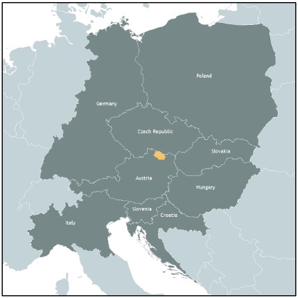
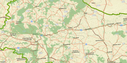
The Lower Austrian case study area of MaGICLandscapes project covers the districts of Horn and Hollabrunn and is a transition area between two landscapes, the Waldviertel in the west and the Weinviertel in the east. The Waldviertel is shaped by the highlands of a shallow gneiss landscape. The River Thaya partially marks the northern border to the Czech Republic and gives its name to the trans-boundary Thayatal National Park /Podyjí National Park, recognised as an outstanding biodiversity hot spot. The Weinviertel is characterised by wide open valleys and rolling hills. The area is one of the driest parts of Austria and lacks distinctive river networks. There are more meadows and less wetlands compared to the Eastern Waldviertel and due to the Pannonian climate and the loess soil it is Austria’s largest wine growing region. River regulation and drainage associated with arable farming means many wet meadows and waterlogged habitats have been lost. On steeper hillsides and knolls the landscape becomes more varied with viticulture interspersed by patches of dry and xeric grassland as well as heath. At slightly higher elevations warm temperate oak forest can be found. The vegetation in this area is unique, home not only to Pannonian species but also species normally found much further to the east such as the European ground squirrel (Spermophilus citellus). Due to its high biodiversity large areas of the case study area are part of the Natura 2000 Network.
Issues
The landscape of the case study area is typically characterised by narrow partitioned strips of farmland with many field margins and boundary ridges. Due to changes in agriculture, increasing intensive cultivation and abandonment of small and unattractive sites, parts of the landscape nowadays are pretty much cleared and featureless.
Existing migration axes and gaps in the GI-network have to be identified and several disconnected Natura 2000 areas should be linked. A main issue is the need to recreate ecologically relevant landscape elements taking into account of the private economic interests of local land managers. Grasslands and streams in the Waldviertel and dry and xeric grasslands in the Weinviertel have been identified as priorities for action. The large-scale spread of the invasive False Acacia (Robinia pseudoacacia) on abandoned meadows, dry and xeric grassland, woodlots and hedges seriously affects the quality and functionality of GI elements in the region. In the more wooded western part of the case study area, the Waldviertel, monotone species-poor plantations of spruce dominate extensive parts of the landscape.
Challenges
Due to the rural character of the region, containing 44 municipalities with just 4 larger cities and covering a relatively large area of nearly 1,800 km², a major challenge is the absence of an overarching instrument for spatial and in particular landscape planning. Thereby the broad scope of tasks for small municipal administrations seldom allows for an intensive involvement in side issues like green infrastructure (GI) or nature conservation at the local level. Providing an easy to use inventory of GI regarding its spatial structure, functionality and ecosystem services on regional and local level can supply decision-support for politicians, planners, land users/managers and communities to invest in GI and will support the further implementation of GI.
HOW THE STRATEGY WAS DEVELOPED
Outline of key themes, priorities and directions for the GI Strategy and Action Plan
As a result of stakeholder involvement and application of various tools to assess the public benefit of GI, a prioritisation of the key aspects of local GI was achieved and provided the basis for the coordinated development of strategies and action plans for the Eastern Waldviertel and Western Weinviertel.
GI Benefit | Strategic Tools/Policies | Partners |
| Conservation benefits | - Maintaining/enhancing existence value of habitat, species and genetic diversity - Maintaining/enhancing bequest and altruist value of habitat, species and genetic diversity for future generations | - Thayatal National Park |
| Tourism & Recreation | - Increase in tourist attractiveness of the territory - Expansion of range and capacity for recreational opportunities | - State and municipalities - Tourism associations |
| Disaster Prevention | - Enhancing erosion control capacity - Reduction of the risk of forest fires - Flood hazard reduction | - State and municipalities - Water board - Climate Change Adaptation Model Regions |
| Land & Soil Management | - Reduction of soil erosion - Maintaining/enhancing soil’s organic matter - Increasing soil fertility and productivity - Mitigating land take, fragmentation and soil sealing - Improving land quality and making land more attractive - Higher property values | - State and municipalities - District agricultural authorities - Chamber of Agriculture - Winegrowers' Association - Federal Ministry of Agriculture, Regions and Tourism - Climate Change Adaptation Model Regions |
| Agriculture & Forestry | - Enhancing multifunctionality and resilience of agriculture and forestry - Enhancing pollination - Enhancing pest control | - State and municipalities - District agricultural authorities - Chamber of Agriculture - Winegrowers' Association - Austrian Federal Forests - Federal Ministry of Agriculture, Regions and Tourism - Climate Change Adaptation Model Regions |
| Investment & Employment | - Better image - More investment - More employment - Increase in labour productivity | - State and municipalities - Tourism associations - Chamber of Agriculture - Climate Change Adaptation Model Regions |
According to this prioritisation and the data driven analysis, the following actions and areas of intervention were identified as most urgent:
- Action Plan 1 - Enhancement of the cleared, arable dominated cultural landscape by re-cultivating it with landscape elements such as hedges, field margins or flower strips
- Action Plan 2 - Climate-friendly forest conversion of spruce plantations with tree species appropriate to the location and designation of natural forest reserves
- Action Plan 3 - Creation of retention and buffer areas, widening of water bodies, promotion of small water bodies and increase of structural diversity in river beds and bank areas of water bodies and wetland habitats for ecological upgrading, raising of the groundwater level and improvement of flood protection
- Action Plan 4 - Securing and improving green infrastructure in areas of fruit and wine growing complexes by preserving and returning to the traditional small-scale cultural landscape and its numerous intermediate structures such as slopes, rows of trees and individual trees.
- Action Plan 5 - Targeted maintenance and resumption of traditional forms of use such as mowing and grazing of the remaining dry grasslands, meadows and pastures which, as scattered residual areas within the intensively used cultural landscape.
- Action Plan 6 - Improvement measures for green areas close to settlements, such as home gardens and parks as well as accompanying areas of road and rail infrastructure offer the possibility to improve the environmental conditions in the villages and towns and to increase the quality of life of the people.
- Action Plan 7 - Securing and establishing habitat corridors to re-connect protected areas, improve an effective biotope network and increase the connectivity of the landscape.
Key Players/actors in delivering the strategy and those that support its implementation
The strategy and action plans are supported by institutions, individuals and municipalities in the case study area and the findings, recommendations of the project will be used to ensure that policy-making and decisions improve the GI resource. Local land owners and managers and nature conservation bodies are encouraged to use the findings to safeguard and improve the functionality of the existing and planned GI network.
Expected benefits
The implementation of concrete measures of the developed action plan will contribute positively to the safeguarding of and, ideally, expansion of the provision of GI benefits regarding, amongst others, conservation, tourism and recreation, disaster prevention, land and soil management, agriculture and forestry as well as investment and employment greatly. By promoting and improving green infrastructure associated with the agricultural landscape, forests and woods, watercourses, still waters and wetlands, fruit and wine growing complexes, dry grasslands, meadows and pastures as well as urban and rural settlements the multifunctional role of these areas providing a wide range of benefits could be further increased to serve human well-being. In addition, though cross-linking and the re-connection of the fragmented GI network, migration and dispersal possibilities of wildlife will be improved, helping to protect ecological fitness, genetic variability and biodiversity.
Download the full strategy here (Deutsch)

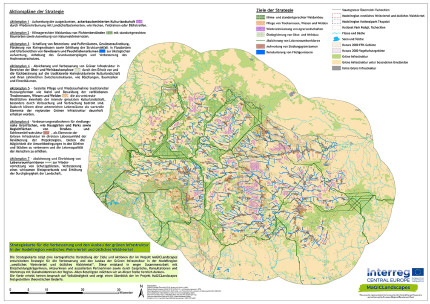
GI Strategy Map of Eastern Waldviertel & Western Weinviertel
Contact
If you live and work in the Eastern Waldviertel or Western Weinviertel and if you are interested in the strategy for a better green infrastructure in this region please feel free to contact magiclandscapes.cvl(at)univie.ac.at at the University of Vienna.
Header photo: Florian Danzinger
Back to WP3 OVERVIEW | CASE STUDY AREA | MAIN PAGE
