Work Package 2
Green Infrastructure Functionality Assessment: Data acquisition at regional and local level
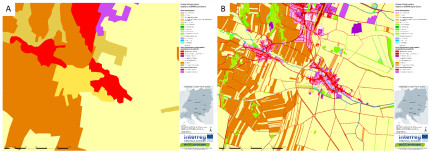
As with any other mapping approach, high quality geodata regarding spatial and thematic resolution is an essential prerequisite to allow the operationalisation of the GI concept in the first place. While the standardised CORINE Land Cover (CLC 2012) database was considered the most adequate for the mapping of GI on a transnational scale, there is no one-size-fits-all solution for the acquisition of suitable geodata at the regional and local level.The use of the highly detailed geodata set revealed differences in the realistic representation of the GI network in the partner countries and regions.

Fig. 1: Fig. 1: Map of GI elements based on CORINE Land Cover (A) and based on regional geodata (B)
Through the compilation of various forms of local data to produce a regional highly detailed geodata set, the mapping quality of GI can be enhanced for all types of landscapes and constitutes a precondition to develop stakeholder-based strategies and action plans for future actions and investments in GI.
The assessment and mapping of GI functionality carried out in MaGICLandscapes comprised three main types of sub-analyses:
- the connectivity analysis
- the field mapping methodology
- the functionality analysis itself.
Back to WP2 OVERVIEW
Read on with WP2: CONNECTIVITY ANALYSIS
Back to MAIN PAGE
