Work Package 2
Green Infrastructure Functionality Assessment:
Connectivity Analysis
The analyses of connectivity were performed through the software GuidosToolbox (Graphical User Interface for the Description of image Objects and their Shapes). GuidosToolbox is a free software collection by Peter Vogt (JRC - Joint Research Centre of the European Commission) and offers a variety of modules targeted to investigate several spatial aspects of raster image objects, for example pattern, connectivity, cost, fragmentation, etc. Below, the three outputs of conducted connectivity analyses are visualised. For more information about the detailed processing we recommend to have a look into Output 1: Manual of Transnational Green Infrastructure Assessment.
Morphological Spatial Pattern Analysis (MSPA)
The MSPA performs a segmentation on a binary image to identify and localise mutually exclusive morphometric feature classes describing the shape, connectivity and spatial arrangement of image objects by mapping and classifying them into categories. The MSPA module automatically detects geometry and connectivity of the image components. Therefore, the foreground area of a raster based binary image is partitioned into seven MSPA classes: Core, Islet, Perforation, Edge, Loop, Bridge and Branch.
Within MaGICLandscapes project the application of MSPA was based both on the transnational and the regional dataset. We used eight-neighbour connectivity and an effective edge width value of 100 metres, at varying prerequisites regarding the pixel size of the input data, for the analysis on the transnational dataset. On the regional dataset, dealing with a pixel size up to 1 metre, the best results could be elaborated with an effective edge width value of 10 metres.
The input data are the raster (grid) maps of the green infrastructure maps of the case study areas. The input map must contain the two data classes: Foreground (GI) and Background (not GI). Therefore, the category “partly GI” has to be resolved and assigned unambiguously to the categories “GI” or “not GI”.
The figures below show the results of the MSPA based on the transnational (Fig. 2) and regional dataset (Fig. 3), for the Austrian case study areas “Eastern Waldviertel & Western Weinviertel” and “Thayatal National Park”. Fig. 4 compares detail sections of the transnational and regional analyses.
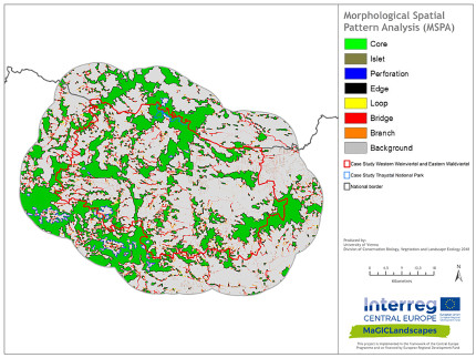
Fig. 2: MSPA on transnational dataset |
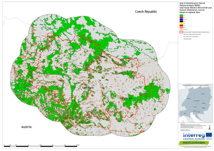
Fig. 3: MSPA on regional dataset |
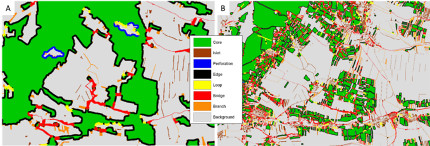
Fig. 4: Comparison of transnational and regional results of the MSPA |
Network Analysis
In order to perform the network analysis, the result of the MSPA analysis is used to create an image of the network of GI elements consisting of Nodes (MSPA class: Core) and Links (MSPA class: Bridge, respectively connectors between various Cores). All other MSPA classes, not contributing to the network are neglected. For further analysis of the network of green infrastructure in the MaGICLandscapes case study areas we analysed the so-called NW Components and the Node/Link Importance.
Fig. 5 shows the results of the Network Analysis based on the transnational dataset, for the same case study chosen for the MSPA. The Austrian case study areas show that interspersed mixed formations of complex cultivation patterns and woodland “islands” form the backbone (dark grey) of important Cores of the extended case study area. On the other hand, Links (highlighted in red) are mostly represented by streams, well equipped with adjacent structures of GI or buffer zones like riparian strips or woodlands and wet meadows. Moreover, linear corridors of complex formations of cultivation patterns mixed with dry grasslands represent very important Links in the case study area.
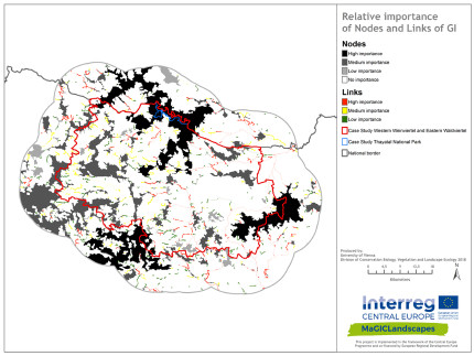
Fig. 5: Network Analysis
Euclidean Distance
To measure the degree of intactness, shape and spatial arrangement of patches on a given binary map, which was also used for the MSPA, the analysis methodology of Euclidean Distance and Hypsometric Curve (HMC) offers a practical and effective method of implementation. The module of Euclidean Distance and HMC analysis scheme is also available in GuidosToolbox and uses the same input data as the MSPA described above.
Fig. 6 shows the results of the Euclidean Distance based on the transnational dataset for the case study areas “Eastern Waldviertel & Western Weinviertel” and “Thayatal National Park” (AT). In comparison Fig. 7 shows the results from the regional and local implementation of Euclidean Distance for the Austrian case study areas. It demonstrates a much more detailed picture on the influence zones of GI elements. Due to the inclusion of further small GI elements like rivulets, embankments, roadside greenery, house gardens and green spaces the cross-linking possibilities within the case study area come fully to attention. On the other hand, comprehensive non-fragmented elements seem to be highly influenced by fragmentation through the presence of an exhaustive transport network or interspersed areas of intensively used arable land. Exemplary Fig. 8 depicts detail sections of the results of the Euclidean Distance based on CORINE Land Cover (A) and based on regional geodata (B).
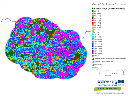
Fig. 6: Euclidean Distance on transnational dataset |
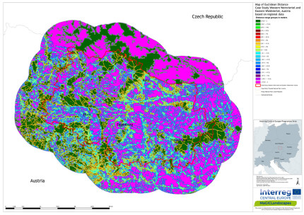
Fig. 7: Euclidean Distance on regional dataset |
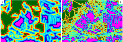
Fig. 8: Comparison of transnational and regional results of Euclidean Distance analysis |
The interpretation of maps of the Euclidean Distance analysis is a bit more complicated but can be rather easily explained: pink colours show spaces that lack any GI and therefore are priority areas for GI implementation. Green and red colours show very good GI presence, while yellow and blue colours show presence of GI that could be improved.
Due to the resolution of spatial data available from the transnational application the results of the three analysis procedures provide fundamental insights and allow the development of transnational and supra-regional concepts dealing with GI. The intuitive analysis schemes of MSPA and Euclidean Distance can be related to further spatial planning measures and are also easy to communicate.
Back to WP2 OVERVIEW
Read on with WP2 FIELD MAPPING METHODOLOGY
Back to MAIN PAGE
