Building capacities of Carpathian protected areas managers
Old-fashioned habitat mapping methods are time-consuming, they often need special expertise and tend to be rather expensive. Effective, integrated, science-based nature conservation management planning needs innovative tools, methods and capacity building. To face this challenge, this work package provides platform for international cooperation and experience exchange to address and share best practices in biodiversity and site management.
The base of a new approach for habitat management planning was developed through the introduction of innovative tools and methodologies for habitat mapping and evaluation. During the project lifetime, a forest state assessment methodology was introduced as an innovative technique to serve multi-aspect and small-scale evaluation of forests. The protocol was evaluated and finalised based on the methodology for monitoring the change in semi-natural forest habitats.
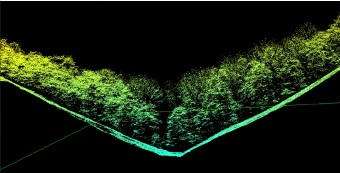
Next to the forest evaluation methodology a new evaluation of grasslands was developed and tested for management planning. To showcase innovative tools, LIDAR, a light detection and ranging tool was introduced for monitoring the topography, species and habitat diversity. The LiDAR scan provides the base for a more effective and long-term nature conservation planning. The LiDAR tool was tested on a pilot action in two habitats: a mountainous and a river valley in the Danube-Ipoly National Park.

LIDAR - A 3D remote sensing technology, a surveying method that measures distance to a target by illuminating the target with laser light and measuring the reflected light with a sensor.
The results were evaluated on an expert workshop, that lead to the preparation of nature conservation management plan for Börzsöny mountains in Hungary, as well as the development of guidelines for proper integrated nature conservation planning.
Work package achievements
D.T2.1.1 Centralparks Workshop report about LiDAR and forest state evaluation toolkit
D.T2.1.2 Forest state evaluation protocol
D.T2.1.3 Grassland state evaluation protocol
D.T2.1.4 Evaluation of the LiDAR results and feasibility study for public authorities
D.T2.1.5 Habitat Mapping Guidelines
D.T2.2.2 Habitat Mapping of Börzsöny Mountains
D.T2.2.3 Forest state evaluation
D.T2.2.4 Grassland state evaluation
D.T2.2.5 Forest fauna evaluation
D.T2.2.7 Nature Conservation Management Plan for Börzsöny Mountains
D.T2.2.9 Summary report based on nature conservation management planning
